About FLY is FUN Aviation Navigation
FLY is FUN is designed by pilots for pilots. FLY is FUN simplify flight preparation and improve situation awareness during flight, providing information on airspaces, reporting points, position on moving map, elevation,...
FLY is FUN is designed by pilots for pilots. FLY is FUN simplify flight preparation and improve situation awareness during flight, providing information on airspaces, reporting points, position on moving map, elevation, frequencies, railway, weather info … facilitate access to airfields related PDF document. Application also displays NOTAMs and data from rainfall radars.
FLY is FUN simulates ILS approach, VOR, NDB, DME, Marker beacons, RNAV navigation and Marker beacons warnings, without ILS/VOR/NDB/RNAV equipment on board.
You can test FLY is FUN for free during few days. At the end of the trial period, pilot is invited to subscribe and pay an annual fees. Doing it, he get the right of using the application "as it is" and contribute to development effort.
FLY is FUN allows:
- Creating and modifying routes using "drag and drop", "rubber band"
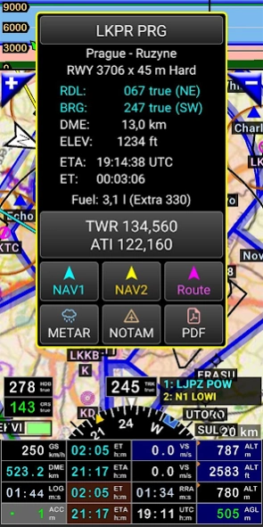
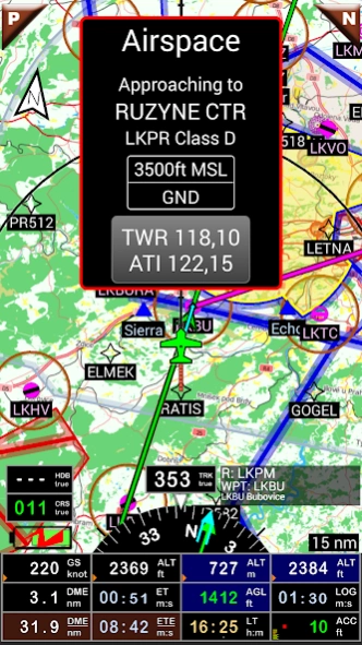
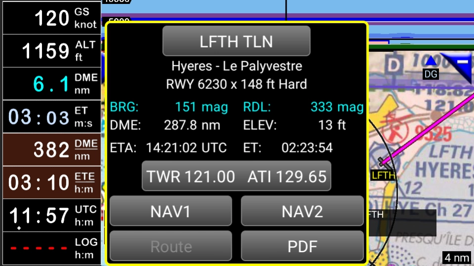
- Getting warnings, alarms and radio info before entering controlled or special use airspaces, approaching points
- Performing route planning, evaluating distance, time and fuel consumption (depending on wind and aircraft characteristics)
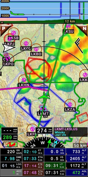
- Displaying route, bearing, trace on moving map
- Visualizing airspace
- Getting dynamic terrain map (colors depending of elevation above ground level)
- STRATUX support
- Creating and exporting Flight Plan
- Creating and exporting Flight log
- Creating, importing or exporting routes, waypoints, RWY, airspace (Garmin .gpx, .kml, txt, OpenAir)
- Recording the flight and playing it back with Google Earth
- Sunset / Sunrise
- Getting weather forecast along the route
- Rainfall radar
- Wind displaying
- Calculating distance between 2 points on the map
- VACs
- Notepad
…
All main screens (5 portrait and 5 landscape could easily be customized. Pilot can choose from around 100 values to display. Example:
- Altitude GPS or barometric
- Ground speed
- Bearing
- Vertical speed
- DME to next point / destination
- Estimated time to next point / destination
- Time since departure
- Stop watch
…
Displayed information could be customized too depending of users preferences (VFR, IFR or both) and zoom level. The more you zoom IN, the more detail, information, waypoints,.. you see
Logbook
The integrated logbook, allows recording:
- Duration since departure time
- Departure and arrival time
- Departure and arrival airport
- Flight track (it is possible to export it as .kml or .gpx and to replay it)
- Used aircraft
- Pilot(s) and copilots in charge
- Distance, average speed, maximum speed
…
Navigation data available from open source database are updated according AIRAC cycles.
Charts and elevation dta
Free charts and elevation data are available for most of countries and could be imported directly via the application store.
Other charts could be created and imported by the pilot itself or made on request available as commercial service.
Pilots could select the most appropriate charts: free open source charts as well as commercial charts as ICAO, Cartabossy, SkyVector, FAA sectional and terminal charts…
VACs and PDF files
VAC and AIP infos are available for more than 50 countries
User can easily attach your own PDF files.
Usage of external GPS connected via Bluetooth is possible
User guide: http://www.funair.cz/downloads/manuals/flyisfun.pdf
If you have any suggestion to improve this application or you find some bug please visit www.flyisfun.com
Use this application for VFR FLYING ONLY!!! We are not responsible for any use of this application.
Previous Versions
Here you can find the changelog of FLY is FUN Aviation Navigation since it was posted on our website on 2014-06-13 08:58:55.
The latest version is 33.20 and it was updated on 2024-04-19 18:42:26. See below the changes in each version.
FLY is FUN Aviation Navigation version 33.20
Updated At: 2024-03-25
Changes: Version 33.20
- Removed bug: when Logbook had a lot of entries, the app crashed when editing the entries.
Version 33.12
- Refactored Route summary
- Removed some bugs
FLY is FUN Aviation Navigation version 33.12
Updated At: 2024-03-22
Changes: - Refactored Route summary
- Removed some bugs
FLY is FUN Aviation Navigation version 33.00
Updated At: 2024-02-20
Changes: - Refactored Airspaces list, VHF list, Logbook list, Route list, Route edit, Route summary, Flight plan list, Nav item edit, Pilot list,
- Refactored Aircraft list
- Document picture viewer did not turn photos orientation using EXIF data
- Added internal PDF viewer used when you display PDF airport document. This can be turned to external PDF viewer in Preferences (General settings)
- When is Route edit opened, you can set wind to all route WPTs from METAR.
- A lot of small improvements
FLY is FUN Aviation Navigation version 32.11
Updated At: 2024-01-24
Changes: - You can display bubble messages on top of the screen (Preferences, Screen settings / Display bubble message on top)
- You can choose to display the vertical view for portrait and landscape mode separately for map and terrain screens.
- Refactored VHF and Airspaces windows.
- The back key always meant to close the window. Now if the window contains a list the back key is used to "go up a level" and only if it can't, the window is closed. This option can be turned off in preferences.
FLY is FUN Aviation Navigation version 32.05
Updated At: 2023-11-03
Changes: Version 32.05
- Removed bug: Open airport url crash
Version 32.04
- Removed bug at map screen: When you zoom in, sometimes vertical situation was not displayed (terrain and airspaces).
Version 32.02
- METAR and TAF data source change. The original one was suspended.
- Export / Import navigation database with folder's notes
- Removed bug: Notification icon was hidden at Android 13
FLY is FUN Aviation Navigation version 32.04
Updated At: 2023-10-26
Changes: - Removed bug at map screen: When you zoom in, sometimes vertical situation was not displayed (terrain and airspaces).
- METAR and TAF data source change. The original one was suspended.
- Export / Import navigation database with folder's notes
- Removed bug: Notification icon was hidden at Android 13
FLY is FUN Aviation Navigation version 32.02
Updated At: 2023-10-22
Changes: - METAR and TAF data source change. The original one was suspended.
- Export / Import navigation database with folder's notes
- Removed bug: Notification icon was hidden at Android 13
FLY is FUN Aviation Navigation version 32.00
Updated At: 2023-10-01
Changes: - Navigation database has a new design. Route windows will follow.
- It is possible to control some FIF features by text file - Config.info. I will publish more information at http://www.funair.cz/forum/
- Removed minor bugs.
FLY is FUN Aviation Navigation version 31.62
Updated At: 2023-08-26
Changes: Version 31.62
- Internal changes
Version 31.60
- New maps for Europe Top Plus Open. Menu / Downloads / Topographical maps
- Internal changes
- Unlocker is not used any more due to Google privacy policy
- Removed bug - When you tap TMA sometimes was shown TWR FRQ. Correct is APP or RDR.
FLY is FUN Aviation Navigation version 31.60
Updated At: 2023-05-22
Changes: - New maps for Europe Top Plus Open. Menu / Downloads / Topographical maps
- Internal changes
- Unlocker is not used any more due to Google privacy policy
- Removed bug - When you tap TMA sometimes was shown TWR FRQ. Correct is APP or RDR.